Intermediate Road Biking Routes
Special thanks to the St. Joseph Area Transportation Study Organization for the following routes, descriptions, and images! For more detailed information about the routes listed below and road cycling safety tips, click here for the full SJATS cycling guide.
Pony Express Ride
Starting Point: YMCA Parking Lot
Route to Follow: Ride along U.S. 36 Highway west to Troy, KS, then return.
Facility Type: Two-lane road with shoulders
Approx. Miles: 30
Terrain: A Few Hills (2–4)
What You’ll See:
Wathena: Convenience stores, historic downtown, restaurants, fruit markets (in season)
Troy: National Register courthouse, Peter Toth Indian Monument, historic downtown
Rest Stops: 2 miles east of Troy

Nodaway
Starting Point: Northside Complex (Krug Park)
Route to Follow: St. Joseph Ave → "K" Hwy past Camp Geiger → Hoffelmeyer Hill → Amazonia → Left on "T" Hwy to Nodaway. Return via same route.
Facility Type: Two-lane road without shoulders
Approx. Miles: 25
Terrain: A Few Hills (2–4)
What You’ll See:
Amazonia: Convenience store, apple orchards
Missouri River Bluffs and farm fields
Rest Stops: None
Note: Yell "Yahoo!" when descending Hoffelmeyer Hill

Savannah Slide
Starting Point: Northside Complex (Krug Park)
Route to Follow: St. Joseph Ave → "K" Hwy → Amazonia → Right on "T" Hwy → Savannah → Hwy 71 South → Ashland → Karnes → Return
Facility Type: Two-lane road without shoulders and four-lane highway with gravel shoulders
Approx. Miles: 25
Terrain: Hilly
What You’ll See:
Amazonia: Apple orchards
Savannah: Duncan Hills Golf Course, Andrew County Museum, historic downtown
Rest Stops: Dairy Queen or Casey's General Store in Savannah

Savannah Shuffle
Starting Point: Northside Complex (Krug Park)
Route to Follow: "K" Hwy → Amazonia → Right on "T" → Savannah → Right on "DD" → Right on U.S. 59 → Return
Facility Type: Two-lane roads without shoulders
Approx. Miles: 25
Terrain: Hilly
What You’ll See:
Rolling hills, Missouri River bluffs
Rest Stops: Convenience store on “T” west of Savannah

DeKalb Cemetery
Starting Point: Southside Complex (Hyde Park)
Route to Follow: King Hill Ave → "V" Hwy → Right on "JJ" → Ride bluffs to DeKalb Cemetery → Return
Facility Type: Two-lane roads without shoulders
Approx. Miles: 22
Terrain: Hilly
What You’ll See:
Beautiful countryside, bluffs, panoramic views
Rest Stops: None

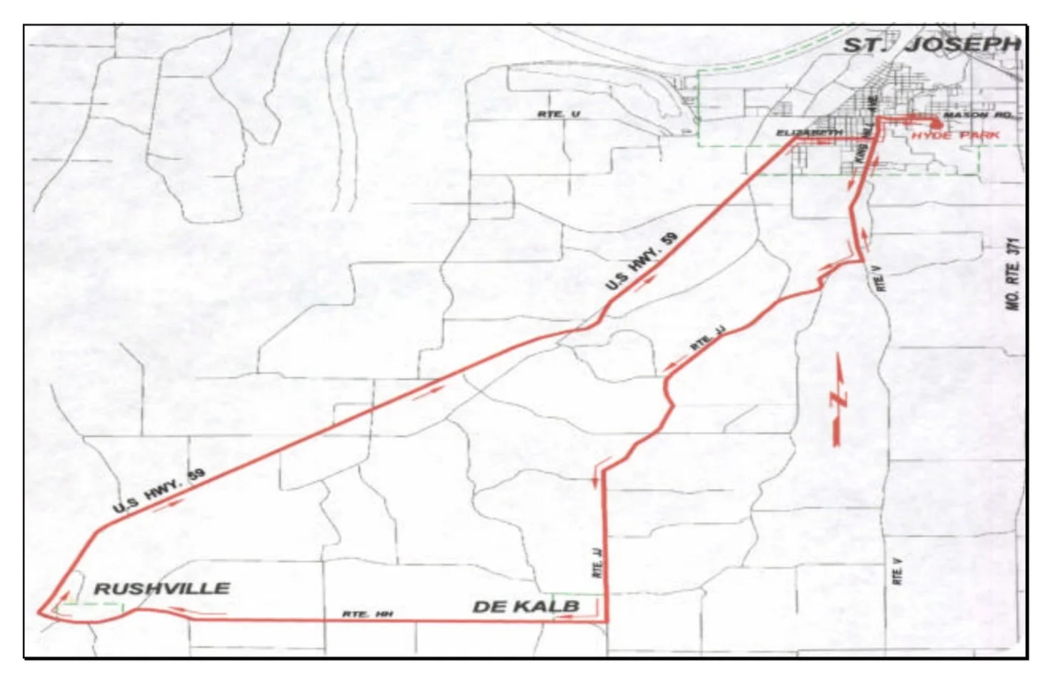
DeKalb–Rushville Experience
Starting Point: Southside Complex (Hyde Park)
Route to Follow: King Hill Ave → "V" → "JJ" → DeKalb → "HH" → Rushville → U.S. 59 → Elizabeth → King Hill Ave → Return
Facility Type: Two-lane roads without shoulders
Approx. Miles: 35
Terrain: Hilly
What You’ll See:
Rolling terrain from DeKalb to Rushville—fun or painful depending on wind
Rest Stops: None—bring extra water
Faucett Flash
Starting Point: Bode Middle School
Route to Follow: Noyes → Parkway → Urban Trail → Pickett → Leonard → 169 → "A" → 371 → 116 → "V" → Return
Facility Type: Two-lane roads without shoulders
Approx. Miles: 40
Terrain: Hilly
What You’ll See:
Long stretches for strong riders
Rest Stops: Only at King Hill & Alabama convenience store

Savannah & Back
Starting Point: Northside Complex (Krug Park)
Route to Follow: U.S. 59 → "DD" → Savannah → "T" → Hwy 71 → Return
Facility Type: Half two-lane, half four-lane divided highway
Approx. Miles: 24
Terrain: Hilly
What You’ll See:
Bluffs and north city outskirts
Rest Stops: Dairy Queen or Casey’s General Store in Savannah

Ice to Agency
Starting Point: Bode Ice Arena (28th & Commercial)
Route to Follow: Pickett → Ajax → Easton → "FF" → Agency School → Return
Facility Type: Two-lane roads without shoulders
Approx. Miles: 18
Terrain: A few hills
What You’ll See:
Site of the Iowa Indian Agency
Rest Stops: None

Pickett–Riverside Ride
Starting Point: Bode Ice Arena
Route to Follow: Pickett → Ajax → Easton → Riverside → Pickett → Return
Facility Type: Two-lane roads without shoulders
Approx. Miles: 15
Terrain: A few hills
What You’ll See:
Changing floral displays at old Pig Farm
Rest Stops: None

San Antonio
Starting Point: Mosaic Life Care
Route to Follow: Riverside → Frederick Blvd → "Z" → U.S. 36 → Return
Facility Type: Two-lane roads without shoulders
Approx. Miles: 15
Terrain: Flat
What You’ll See:
Busy corridor—be cautious
Rest Stops: Convenience store at Riverside/Frederick
